

share to:


Super Typhoon Ragasa continued to approach Shenzhen early Wednesday, bringing intensifying winds and heavy rain as authorities urged residents to remain on high alert.
As of 5 a.m., the storm's center was located 162 kilometers southeast of Shenzhen over the South China Sea, according to the National Meteorological Center. Ragasa, this year’s 18th typhoon, maintained super typhoon status, with maximum sustained winds near the center reaching level 16 (55 meters per second) and a central pressure of 930 hPa.
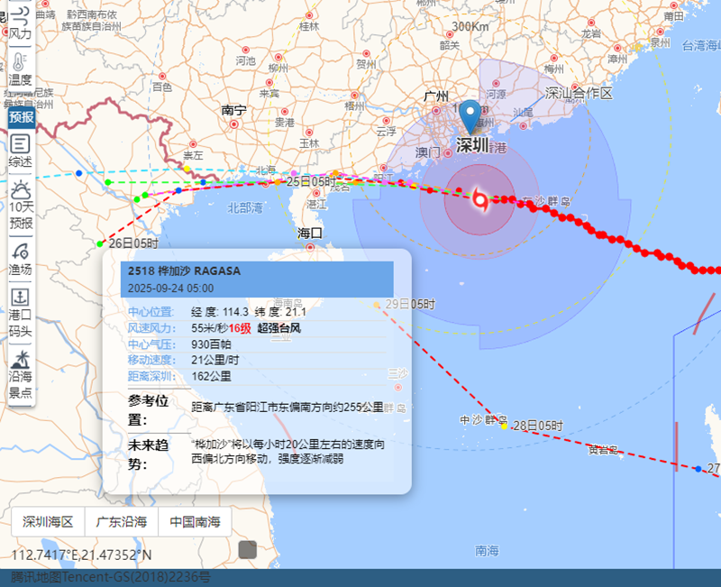
The eye of Typhoon Ragasa was located 162 kilometers southeast of Shenzhen as of 5 a.m. on Sept. 24, with maximum sustained winds of 55 m/s (level 16).
The storm's wind field extended widely, with:
7-level winds covering a radius of 250–380 kilometers,
10-level winds spanning 150 kilometers,
and 12-level winds reaching 90 kilometers from the center.
Typhoon expected to skirt south of Shenzhen
Meteorologists forecast that Ragasa will move westward at a speed of 20 to 25 kilometers per hour, maintaining its strength. Between 6 a.m. and 9 a.m., the typhoon is expected to pass offshore, approximately 140 kilometers southwest of Shenzhen, heading toward the coastal area between Taishan and Dianbai in Guangdong Province.
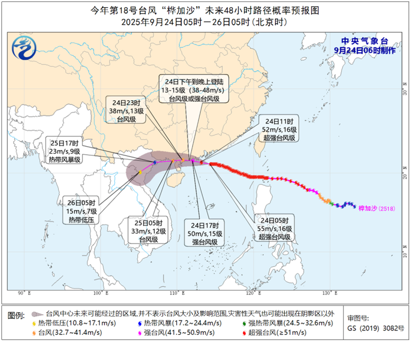
Typhoon Ragasa is forecast to pass near the coastal region between Taishan and Dianbai in Guangdong Province between the afternoon and evening today, with wind intensity reaching level 13–15 upon landfall.
Strong winds recorded across Shenzhen
Between 3 a.m. and 6 a.m., monitoring stations across the city recorded widespread gusts, excluding highlands and islands:
The highest gust reached level 13 (39.6 m/s) at Xinda Station in Dapeng New District.
The highest average wind speed was level 11 (30.5 m/s), at Chuanbiyen Station.
Out of all monitoring points:
104 stations reported gusts of level 8 or above,
23 stations exceeded level 10,
4 stations recorded level 12 or above.
District-level peak gusts included:
Dapeng: level 13 (40.7 m/s)
Yantian: level 12 (31.4 m/s)
Shenshan, Luohu: level 11 (28.8 m/s)
Bao’an, Guangming: level 10
Futian, Nanshan, Pingshan: level 9
Longgang, Longhua: level 8
In highland and offshore areas, Qiniangshan Station in Dapeng New District recorded a gust of level 15 (49.4 m/s).
Winds and rain expected to intensify
In the next three hours, wind speeds are expected to increase by 1–2 levels across most areas:
On land, gusts may reach levels 9–11.
Southern coastal areas may see levels 12–14.
Highlands and eastern sea areas could experience gusts up to levels 15–16.
Wind direction is shifting from northeasterly to easterly, and will turn onshore, increasing the risk of storm surges and coastal flooding. Authorities warned coastal residents to take extra precautions.
Rain bands from the typhoon are expected to bring frequent and intense rainfall across the city within the next hour, especially in eastern and southern districts. Rainfall intensity may reach 20–30 millimeters per hour.
Stay updated
Residents are urged to stay informed through official sources such as the Shenzhen Weather app, the city's official Weibo (深圳天气) and WeChat (深圳天气) channels, and government websites for the latest forecasts and warnings.


